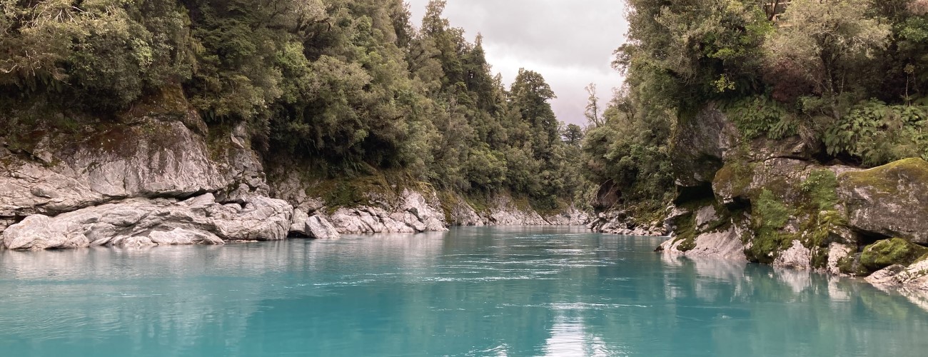
Hokitika Gorge Walkway is a popular short walk that showcases the stunning turquoise water of the Hokitika River as it flows through a narrow granite gorge. The walk is located 30 minutes drive out of Hokitika.
| Details | |
| Length | 2 km |
| Time Required | Allow 45 min |
| Trail Type | Walking track (with wheelchair access) |
| Physical Difficulty | Easy |
| Uses | Walking |
| Direction | Either |
| Dog Access | Dogs are prohibited |
If any layers fail to load, try clearing your cache and refreshing the page.
Hokitika Gorge Walkway does not connect to any other official tracks.
30 min from Hokitika
From Hokitika, head east along Kaniere Rd. At Kaniere, follow the road as it heads to the right to become Kaniere-Kowhitirangi Rd. The route to the walkway follows narrow country roads with several right angle turns and one-way bridges. Pay attention to the yellow “Hokitika Gorge” signposts to make sure you stay on the right route. The car park at the beginning of the walkway is large, but can fill up quickly during summer and holiday weekends. There is a toilet at the car park.
The walkway is maintained by the Department of Conservation.
Heading in an anti-clockwise direction (beginning next to the toilet block), follow the walkway as it enters the native podocarp forest. After a short distance you’ll reach the first viewing platform, which provides the first view of the river’s blue hue. The well-graded track continues at a gradual descent down toward the edge of the gorge, and features a boardwalk section. After a few more minutes you’ll reach the first suspension bridge across the Hokitika River.
On the other side, the track sidles through lush native bush on the true left of the river, before another track branches off to the left and gives access to the waters edge. The river’s spectacular colour comes from the ‘rock flour’ suspended in its flow; this is finely-ground sediment produced by glacial erosion and washed down from the river’s headwaters high in the Southern Alps. Be careful here; the river current is deceptively strong and signs warn that there have been several drownings.
The walkway continues across Elf Creek and reaches another viewing platform, then crosses a section of boardwalk that clings to the edge of the gorge. You’ll then reach the more recently-built suspension bridge that crosses the river again. At this part of the gorge there is an overflow channel parallel to the river separated by an island, from which rimu and miro grow to have their crowns at the height of the bridge.
The walkway then continues at an easy grade for 600 m through native bush to complete the circuit to the car park.


Hokitika Gorge Walkway is a popular short walk that showcases the stunning turquoise water of the Hokitika River as it flows through a narrow granite gorge. The walk is located 30 minutes drive out of Hokitika.
| Details | |
| Length | 2 km |
| Time Required | Allow 45 min |
| Trail Type | Walking track (with wheelchair access) |
| Physical Difficulty | Easy |
| Uses | Walking |
| Direction | Either |
| Dog Access | Dogs are prohibited |
30 min from Hokitika
From Hokitika, head east along Kaniere Rd. At Kaniere, follow the road as it heads to the right to become Kaniere-Kowhitirangi Rd. The route to the walkway follows narrow country roads with several right angle turns and one-way bridges. Pay attention to the yellow “Hokitika Gorge” signposts to make sure you stay on the right route. The car park at the beginning of the walkway is large, but can fill up quickly during summer and holiday weekends. There is a toilet at the car park.
The walkway is maintained by the Department of Conservation.
Heading in an anti-clockwise direction (beginning next to the toilet block), follow the walkway as it enters the native podocarp forest. After a short distance you’ll reach the first viewing platform, which provides the first view of the river’s blue hue. The well-graded track continues at a gradual descent down toward the edge of the gorge, and features a boardwalk section. After a few more minutes you’ll reach the first suspension bridge across the Hokitika River.
On the other side, the track sidles through lush native bush on the true left of the river, before another track branches off to the left and gives access to the waters edge. The river’s spectacular colour comes from the ‘rock flour’ suspended in its flow; this is finely-ground sediment produced by glacial erosion and washed down from the river’s headwaters high in the Southern Alps. Be careful here; the river current is deceptively strong and signs warn that there have been several drownings.
The walkway continues across Elf Creek and reaches another viewing platform, then crosses a section of boardwalk that clings to the edge of the gorge. You’ll then reach the more recently-built suspension bridge that crosses the river again. At this part of the gorge there is an overflow channel parallel to the river separated by an island, from which rimu and miro grow to have their crowns at the height of the bridge.
The walkway then continues at an easy grade for 600 m through native bush to complete the circuit to the car park.
Hokitika Gorge Walkway does not connect to any other official tracks.
Updated 29 January 2021