Gordon’s Pyramid (1489 m) is a peak on the Arthur Range, in Kahurangi National Park. Its summit has views that rival those of its taller neighbour, Mt Arthur. It can be climbed as a day walk or used as an alternative to Flora-Salisbury Track for trips between Flora car park and Salisbury Lodge.
| Details | |
| Length | 21 km return circuit to Flora car park |
| Time Required | 6-7 hr return circuit to Flora car park |
| Trail Type | Tramping track/Poled route |
| Physical Difficulty | Hard |
| Uses | Walking and trail running |
| Direction | Either |
| Start Elevation | 930 m (Flora car park) |
| Max Elevation | 1540 m |
| Dog Access | Dogs are prohibited in Kahurangi National Park |
If any layers fail to load, try clearing your cache and refreshing the page.
1 hr 15 min from Nelson
Flora car park is the starting point for climbing Gordon’s Pyramid. The car park is located at 930 m elevation, at the end of Graham Valley Road, southwest of Motueka. Graham Valley Road begins off Motueka River West Bank Road near Ngatimoti, and is approximately 65 km from Nelson and 21 km from Motueka. The car park is located 10 km up Graham Valley Road, at the road end. Be aware that Graham Valley Road is steep, narrow and unsealed, and can be icy in winter. A 4WD vehicle is recommended. The road is also prone to slips, so check the DOC website for road access updates.
At the car park there is a toilet, and a shelter named Flora Kiosk, where you can view maps and track information, and enter your intentions in the logbook.
Begin by following Flora Track (a 4WD road) from Flora car park. You will quickly reach Flora Saddle (975 m), where Mt Arthur Track forks to the left. Mt Arthur Track is smooth and wide, and climbs gently onto the crest of a ridge, which it follows in a southwest direction through dracophyllum and stunted mountain beech. After about a kilometre on the ridge the track steepens a little and winds up through elegant silver beech trees towards Mt Arthur Hut. You will reach the hut, which sits just below the tree line at 1310 m, after around 1 hr 15 min.
Just above the hut is a track junction between Mt Arthur Summit Route and the track down to Flora Hut. Turn left here, and climb up onto the ridge amid tussock and alpine shrubs. Though categorised as a route, the track is well-worn and marked with poles. You will soon reach an impressive section of marble pavement, where you’ll get the first glimpse of the summit of Mt Arthur, and enjoy good views in all directions. The ridge is undulating at first, then rises steeply above the eastern side of Horseshoe Basin.
About 1.9 km from Mt Arthur Hut, you’ll reach the turnoff to Gordon’s Pyramid Route. The poled route drops down into Horseshoe Basin, weaving around steep-sided depressions and over glacially-molded marble. The route climbs out the other side of the basin and continues through tussock along a wide spur that gradually becomes narrower; here you’ll leave the Mt Arthur massif and drop onto Pyramid Ridge. The route drops steeply into a saddle and on the other side starts climbing a spur toward the summit of Gordon’s Pyramid, which you’ll enjoy a clear view of as it looms ahead.
The gently-sloping summit offers spectacular views of Kahurangi National Park, with unobstructed views of the Tableland, Leslie Valley and the forested ridges leading toward Takaka Valley.
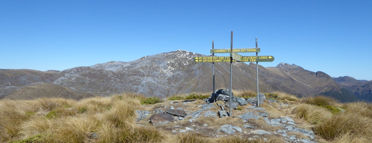
There is a three-way track junction with signage at the summit. To get to Salisbury Lodge, continue straight (northwest) down the spur (1 hr, 3 km away). Otherwise turn right (north) to head down Cloustons Track, which drops steadily through snow tussock to the treeline. Cloustons Mine is just below the treeline. The track follows the east side of Gridiron Valley, descending at a very gentle rate through beech forest for a further 4 km to Flora Track (a 4WD road). Turn right here and follows the undulating road for 3.8 km to Flora Hut, and a further 2 km back to Flora car park.
Gordon’s Pyramid is an alpine environment, so proper preparation and care should be made to ensure a safe trip. The track reaches a high elevation and is exposed above the treeline, so proper outdoor clothing is essential. You must always be prepared for freezing conditions and take extreme care if snow and ice and are present. Be sure to check the forecast for Kahurangi National Park; do not rely on the Nelson or Motueka weather forecasts as the alpine conditions are likely to be drastically different. Make sure you carry plenty of water with you as there are no water sources beyond Mt Arthur Hut. The karst landscape the route traverses is riddled with caves, sinkholes and bluffs. Do not deviate off it, especially in winter, when snow will disguise the true ground surface.
See the Mountain Safety Council website for useful information on preparing for the outdoors.


Gordon’s Pyramid (1489 m) is a peak on the Arthur Range, in Kahurangi National Park. Its summit has views that rival those of its taller neighbour, Mt Arthur. It can be climbed as a day walk or used as an alternative to Flora-Salisbury Track for trips between Flora car park and Salisbury Lodge.
| Details | |
| Length | 21 km return circuit to Flora car park |
| Time Required | 6-7 hr return circuit to Flora car park |
| Trail Type | Tramping track/Poled route |
| Physical Difficulty | Hard |
| Uses | Walking and trail running |
| Direction | Either |
| Start Elevation | 930 m (Flora car park) |
| Max Elevation | 1540 m |
| Dog Access | Dogs are prohibited in Kahurangi National Park |
1 hr 15 min from Nelson
Flora car park is the starting point for climbing Gordon’s Pyramid. The car park is located at 930 m elevation, at the end of Graham Valley Road, southwest of Motueka. Graham Valley Road begins off Motueka River West Bank Road near Ngatimoti, and is approximately 65 km from Nelson and 21 km from Motueka. The car park is located 10 km up Graham Valley Road, at the road end. Be aware that Graham Valley Road is steep, narrow and unsealed, and can be icy in winter. A 4WD vehicle is recommended. The road is also prone to slips, so check the DOC website for road access updates.
At the car park there is a toilet, and a shelter named Flora Kiosk, where you can view maps and track information, and enter your intentions in the logbook.
Begin by following Flora Track (a 4WD road) from Flora car park. You will quickly reach Flora Saddle (975 m), where Mt Arthur Track forks to the left. Mt Arthur Track is smooth and wide, and climbs gently onto the crest of a ridge, which it follows in a southwest direction through dracophyllum and stunted mountain beech. After about a kilometre on the ridge the track steepens a little and winds up through elegant silver beech trees towards Mt Arthur Hut. You will reach the hut, which sits just below the tree line at 1310 m, after around 1 hr 15 min.
Just above the hut is a track junction between Mt Arthur Summit Route and the track down to Flora Hut. Turn left here, and climb up onto the ridge amid tussock and alpine shrubs. Though categorised as a route, the track is well-worn and marked with poles. You will soon reach an impressive section of marble pavement, where you’ll get the first glimpse of the summit of Mt Arthur, and enjoy good views in all directions. The ridge is undulating at first, then rises steeply above the eastern side of Horseshoe Basin.
About 1.9 km from Mt Arthur Hut, you’ll reach the turnoff to Gordon’s Pyramid Route. The poled route drops down into Horseshoe Basin, weaving around steep-sided depressions and over glacially-molded marble. The route climbs out the other side of the basin and continues through tussock along a wide spur that gradually becomes narrower; here you’ll leave the Mt Arthur massif and drop onto Pyramid Ridge. The route drops steeply into a saddle and on the other side starts climbing a spur toward the summit of Gordon’s Pyramid, which you’ll enjoy a clear view of as it looms ahead.
The gently-sloping summit offers spectacular views of Kahurangi National Park, with unobstructed views of the Tableland, Leslie Valley and the forested ridges leading toward Takaka Valley.
There is a three-way track junction with signage at the summit. To get to Salisbury Lodge, continue straight (northwest) down the spur (1 hr, 3 km away). Otherwise turn right (north) to head down Cloustons Track, which drops steadily through snow tussock to the treeline. Cloustons Mine is just below the treeline. The track follows the east side of Gridiron Valley, descending at a very gentle rate through beech forest for a further 4 km to Flora Track (a 4WD road). Turn right here and follows the undulating road for 3.8 km to Flora Hut, and a further 2 km back to Flora car park.
Gordon’s Pyramid is an alpine environment, so proper preparation and care should be made to ensure a safe trip. The track reaches a high elevation and is exposed above the treeline, so proper outdoor clothing is essential. You must always be prepared for freezing conditions and take extreme care if snow and ice and are present. Be sure to check the forecast for Kahurangi National Park; do not rely on the Nelson or Motueka weather forecasts as the alpine conditions are likely to be drastically different. Make sure you carry plenty of water with you as there are no water sources beyond Mt Arthur Hut. The karst landscape the route traverses is riddled with caves, sinkholes and bluffs. Do not deviate off it, especially in winter, when snow will disguise the true ground surface.
See the Mountain Safety Council website for useful information on preparing for the outdoors.
Updated 12 August 2019