Milnthorpe Park Scenic Reserve and Aboretum is a conservation area featuring a network of walking tracks. A short distance from Collingwood, the coastal park is an ongoing forest restoration success story, and is a popular walking destination for locals and visitors alike.
| Details | |
| Length | Varies; there are over 13 km of individual trails to make circuits from |
| Time Required | Allow 30 min as a minimum |
| Trail Type | Walking track |
| Physical Difficulty | Easy |
| Uses | Walking and trail running |
If any layers fail to load, try clearing your cache and refreshing the page.
The Milnthorpe Park track network does not connect to any tracks outside the park, though Collingwood can be reached by heading north along the sandy beach (2.5 km north).
5 min from Collingwood | 20 min from Takaka
There is a small parking area on the righthand side of SH60 (if heading north), about 100 m after the turnoff to Milnthorpe Quay. The entrance is easily missed if approaching at speed. You can also turn onto Milnthorpe Quay and head to the end, where there’s a car park, toilet and a causeway across an arm of Parapara Inlet, providing access to Milnthorpe Beach.
Letterboxes at the main entrances hold paper maps, which have been thoughtfully provided to help guide you around the park; these may come in handy as some of the lesser-used tracks are not always obvious. Donation boxes allow you to help support the Milnthorpe Park Society, which manages the park under an agreement with DOC.
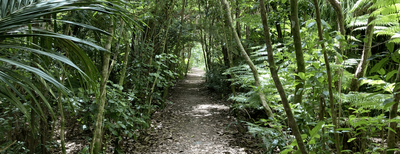
The park is bounded by the sandy Milnthorpe Beach (which runs the length of the park) to the east, Parapara Inlet to the south, and a low ridge to the west and north. The small settlement of Milnthorpe is at the southern end, on the shore of Parapara Inlet. From the beach, the lightly undulating topography gradually rises inland, with small streams flowing in the gullies. The forest makeup varies across the park; in some parts the high canopy makes the subcanopy light and airy, while in others there is an almost impenetrable native understory. Behind the beach is a backdune wetland, and areas of pahiki restrict the vegetation to stunted manuka scrub. On the inland side of SH60, Bell’s Hill Track climbs the ridge to 150 m elevation.
The park is the result of five decades of restoration. In 1974, a plan was made to revegetate the once bare site, though when the initial plantings of natives suffered a low survival rate, exotic species, (mainly eucalyptus and acacia) were tried. These grew well on the poor soils and have acted as a nursery crop, improving the soil and suppressing weed species, which has gradually allowed thousands of native trees and ferns to thrive beneath the shelter of the canopy. Note the abundance of young podocarps (rimu, kahikatea and totara), which will one day form the dominant canopy species. Predator control has helped provide safe habitat for many native bird species.
The trail network allows numerous circuit options (refer to the map). Some tracks are up to a kilometre in length, while others are much shorter and simply act as connections between other tracks. Almost all have signage to help guide you. The sandy Milnthorpe Beach (safe for swimming) can be incorporated in your circuit, with access to three tracks (The Old Road, The Old Master and Redwood Trail) leading back into the park. Two of the inland tracks cross SH60; take care at these points, as approaching vehicles are sometimes difficult to hear.
Milnthorpe Park Scenic Reserve and Aboretum is a conservation area featuring a network of walking tracks. A short distance from Collingwood, the coastal park is an ongoing forest restoration success story, and is a popular walking destination for locals and visitors alike.
| Details | |
| Length | Varies; there are over 13 km of individual trails to make circuits from |
| Time Required | Allow 30 min as a minimum |
| Trail Type | Walking track |
| Physical Difficulty | Easy |
| Uses | Walking and trail running |
5 min from Collingwood | 20 min from Takaka
There is a small parking area on the righthand side of SH60 (if heading north), about 100 m after the turnoff to Milnthorpe Quay. The entrance is easily missed if approaching at speed. You can also turn onto Milnthorpe Quay and head to the end, where there’s a car park, toilet and a causeway across an arm of Parapara Inlet, providing access to Milnthorpe Beach.
Letterboxes at the main entrances hold paper maps, which have been thoughtfully provided to help guide you around the park; these may come in handy as some of the lesser-used tracks are not always obvious. Donation boxes allow you to help support the Milnthorpe Park Society, which manages the park under an agreement with DOC.
The park is bounded by the sandy Milnthorpe Beach (which runs the length of the park) to the east, Parapara Inlet to the south, and a low ridge to the west and north. The small settlement of Milnthorpe is at the southern end, on the shore of Parapara Inlet. From the beach, the lightly undulating topography gradually rises inland, with small streams flowing in the gullies. The forest makeup varies across the park; in some parts the high canopy makes the subcanopy light and airy, while in others there is an almost impenetrable native understory. Behind the beach is a backdune wetland, and areas of pahiki restrict the vegetation to stunted manuka scrub. On the inland side of SH60, Bell’s Hill Track climbs the ridge to 150 m elevation.
The park is the result of five decades of restoration. In 1974, a plan was made to revegetate the once bare site, though when the initial plantings of natives suffered a low survival rate, exotic species, (mainly eucalyptus and acacia) were tried. These grew well on the poor soils and have acted as a nursery crop, improving the soil and suppressing weed species, which has gradually allowed thousands of native trees and ferns to thrive beneath the shelter of the canopy. Note the abundance of young podocarps (rimu, kahikatea and totara), which will one day form the dominant canopy species. Predator control has helped provide safe habitat for many native bird species.
The trail network allows numerous circuit options (refer to the map). Some tracks are up to a kilometre in length, while others are much shorter and simply act as connections between other tracks. Almost all have signage to help guide you. The sandy Milnthorpe Beach (safe for swimming) can be incorporated in your circuit, with access to three tracks (The Old Road, The Old Master and Redwood Trail) leading back into the park. Two of the inland tracks cross SH60; take care at these points, as approaching vehicles are sometimes difficult to hear.
The Milnthorpe Park track network does not connect to any tracks outside the park, though Collingwood can be reached by heading north along the sandy beach (2.5 km north).
Updated 16 November 2023