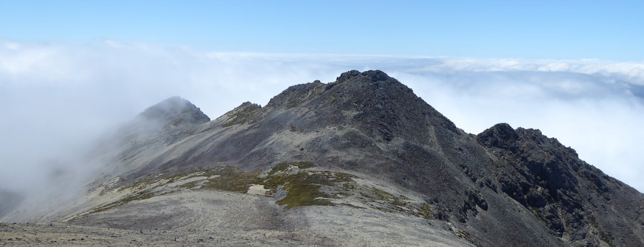
Mt Fishtail (1641 m) is a prominent peak in Mt Richmond Forest Park, in Marlborough. Named due to its twin summits resembling a fishtail from some perspectives, the mountain provides a physically-challenging overnight tramp via Mt Fishtail Track. Initially a leisurely wander though the beautiful native forest of Pine Valley, the track soon transforms into a grueling climb to Fishtail Hut, which is located a few hundred metres below the summit.
| Details | |
| Length | 8.2 km one way to Fishtail Hut; 1.2 km Fishtail hut to Mt Fishtail summit |
| Time Required | 5-6 hr one way to Fishtail Hut; 1 hr 30 min return Fishtail hut to Mt Fishtail summit |
| Trail Type | Tramping track |
| Physical Difficulty | Hard |
| Uses | Walking and trail running |
| Direction | Return (up and down) |
| Start Elevation | 210 m |
| Finish Elevation | 1340 m (Fishtail Hut) or 1641 m (Mt Fishtail summit) |
| Dog Access | Permit required for Mt Richmond Forest Park; see local DOC office |
If any layers fail to load, try clearing your cache and refreshing the page.
Mt Fishtail Track does not connect to any other official tracks.
1 hr 45 min from Nelson | 45 min from Bleheim
Mt Fishtail Track is located on the north bank of the Wairau River, in Wairau Valley. You will need to get onto North Bank Road, which begins immediately north of the Wairau River Bridge on State Highway 6 (5 km north of Renwick). Follow North Bank Road west for 25 km and turn right onto Pine Valley Road; a signpost indicates this is the way to access Mt Fishtail. Follow Pine Valley Road for 5 km until it ends at a small parking area next to Pine Valley Stream. Begin here along the track that follows the true right of the stream. If you have a 4WD vehicle you can ford the stream and continue along the 4WD track on the true left to Mill Flat campsite (which will take 20 mins off your walking time).
High fire risk will close access.
From Mill Flat campsite the track follows the valley floor alongside the true right of Pine Valley Stream, passing through a mix of beech and podocarps with lots of moss on the forest floor. After 20 min you will pass the location of the old Pine Valley Hut, which burnt down in 2014. The gradient is easy-going for the first 3.2 km, after which point the track crosses the stream and immediately begins climbing steeply up a spur. Here you will gain over 500 m elevation in around 1.6 km (a gradient of around 30%). The track is rocky and rooty amid the beech forest. The gradient eases once you’re on the top of the ridge, and openings in the forest allow glimpses of the southern face of Mt Fishtail.
You’ll reach the treeline at 1300 m, at which point the track emerges into alpine scrub and the hut becomes visible in the distance, perched on a tussocky slope above a rock escarpment. The remaining distance to the hut sidles the western face of Fishtail, across a steep scree slope. Be very careful along this section in winter when ice and snow can make the rocks slippery. Fishtail Hut is small and does not have a woodburner for heating.
| Fishtail Hut | |
| Hut Type | Standard Hut |
| Capacity | 4 bunks |
| Bookings | Not required; first in, first served |
| Fee | 1 Standard Hut Ticket |
| Altitude | 1340 m |
There is no official track to the summit. The easiest way is to head up the vegetated area of scree behind the hut. Once you’re at the saddle west of the lower of the two points of the fishtail, it is a straightforward climb along the ridge to the summit at 1641 m. Here you will enjoy spectacular views of the Richmond Ranges, Wairau Valley, and Inland Kaikoura Range. To get back to the hut, return the same way you came.
Mt Fishtail is an alpine environment, so proper preparation and care should be made to ensure a safe trip. The track reaches a high elevation and is exposed above the treeline, so proper outdoor clothing is essential. You must always be prepared for freezing conditions and take extreme care if snow and ice and are present. Do not rely on the Blenheim weather forecast as the alpine conditions in Mt Richmond Forest Park are likely to be drastically different. Make sure you carry plenty of water with you as there are no water sources beyond the valley floor, and in winter the water tank at Fishtail Hut will likely be frozen.
See the Mountain Safety Council website for useful information on preparing for the outdoors.
Mt Fishtail (1641 m) is a prominent peak in Mt Richmond Forest Park, in Marlborough. Named due to its twin summits resembling a fishtail from some perspectives, the mountain provides a physically-challenging overnight tramp via Mt Fishtail Track. Initially a leisurely wander though the beautiful native forest of Pine Valley, the track soon transforms into a grueling climb to Fishtail Hut, which is located a few hundred metres below the summit.
| Details | |
| Length | 8.2 km one way to Fishtail Hut; 1.2 km Fishtail hut to Mt Fishtail summit |
| Time Required | 5-6 hr one way to Fishtail Hut; 1 hr 30 min return Fishtail hut to Mt Fishtail summit |
| Trail Type | Tramping track |
| Physical Difficulty | Hard |
| Uses | Walking and trail running |
| Direction | Return (up and down) |
| Start Elevation | 210 m |
| Finish Elevation | 1340 m (Fishtail Hut) or 1641 m (Mt Fishtail summit) |
| Dog Access | Permit required for Mt Richmond Forest Park; see local DOC office |
1 hr 45 min from Nelson | 45 min from Bleheim
Mt Fishtail Track is located on the north bank of the Wairau River, in Wairau Valley. You will need to get onto North Bank Road, which begins immediately north of the Wairau River Bridge on State Highway 6 (5 km north of Renwick). Follow North Bank Road west for 25 km and turn right onto Pine Valley Road; a signpost indicates this is the way to access Mt Fishtail. Follow Pine Valley Road for 5 km until it ends at a small parking area next to Pine Valley Stream. Begin here along the track that follows the true right of the stream. If you have a 4WD vehicle you can ford the stream and continue along the 4WD track on the true left to Mill Flat campsite (which will take 20 mins off your walking time).
High fire risk will close access.
From Mill Flat campsite the track follows the valley floor alongside the true right of Pine Valley Stream, passing through a mix of beech and podocarps with lots of moss on the forest floor. After 20 min you will pass the location of the old Pine Valley Hut, which burnt down in 2014. The gradient is easy-going for the first 3.2 km, after which point the track crosses the stream and immediately begins climbing steeply up a spur. Here you will gain over 500 m elevation in around 1.6 km (a gradient of around 30%). The track is rocky and rooty amid the beech forest. The gradient eases once you’re on the top of the ridge, and openings in the forest allow glimpses of the southern face of Mt Fishtail.
You’ll reach the treeline at 1300 m, at which point the track emerges into alpine scrub and the hut becomes visible in the distance, perched on a tussocky slope above a rock escarpment. The remaining distance to the hut sidles the western face of Fishtail, across a steep scree slope. Be very careful along this section in winter when ice and snow can make the rocks slippery. Fishtail Hut is small and does not have a woodburner for heating.
| Fishtail Hut | |
| Hut Type | Standard Hut |
| Capacity | 4 bunks |
| Bookings | Not required; first in, first served |
| Fee | 1 Standard Hut Ticket |
| Altitude | 1340 m |
There is no official track to the summit. The easiest way is to head up the vegetated area of scree behind the hut. Once you’re at the saddle west of the lower of the two points of the fishtail, it is a straightforward climb along the ridge to the summit at 1641 m. Here you will enjoy spectacular views of the Richmond Ranges, Wairau Valley, and Inland Kaikoura Range. To get back to the hut, return the same way you came.
Mt Fishtail is an alpine environment, so proper preparation and care should be made to ensure a safe trip. The track reaches a high elevation and is exposed above the treeline, so proper outdoor clothing is essential. You must always be prepared for freezing conditions and take extreme care if snow and ice and are present. Do not rely on the Blenheim weather forecast as the alpine conditions in Mt Richmond Forest Park are likely to be drastically different. Make sure you carry plenty of water with you as there are no water sources beyond the valley floor, and in winter the water tank at Fishtail Hut will likely be frozen.
See the Mountain Safety Council website for useful information on preparing for the outdoors.
Mt Fishtail Track does not connect to any other official tracks.
Updated 26 January 2019