Mt Haast (1587 m) is a prominent peak just west of Rahu Saddle, in Victoria Forest Park. The route to the summit provides a challenging half-day walk and offers spectacular views of the surrounding ranges and valleys. Mt Haast is one of two peaks in the South Island named after Julius von Haast by 19th century explorer James MacKay.
| Details | |
| Distances | 5.5 km return |
| Time Required | 4-5 hr return |
| Trail Type | Tramping track |
| Physical Difficulty | Hard |
| Uses | Walking |
| Start Elevation | 645 m |
| Max Elevation | 1587 m |
If any layers fail to load, try clearing your cache and refreshing the page.
Mt Haast Route does not connect to any other tracks.
10 min from Springs Junction | 30 min from Reefton
Mt Haast Route begins on the southern side of SH7, approx. 2 km west of Rahu Saddle. There is a parking area and a DOC sign that indicates the beginning of the route.
The route enters beech forest and begins climbing steadily. The forest understory initially features many ferns, which gradually peter out as you gain elevation. Dracophyllum and flaxes become present as you near the tree line. The track is well-worn and easy to follow, though being ‘route’ grade there are plenty of steep and rooty sections to negotiate.
After approx. 1 hr 15 min you will reach the tree line at 1250 m elevation. Above here, the route continues steeply through snow tussock and across coarse granite boulder fields. It is reasonably well-worn, though in some places the correct way forward is not immediately obvious, so you will need to rely on the occasional marker poles. This is particularly true if there is snow cover. As you climb the northeastern aspect of the peak, the spur narrows and there are steep drop-offs and gullies to be careful around.
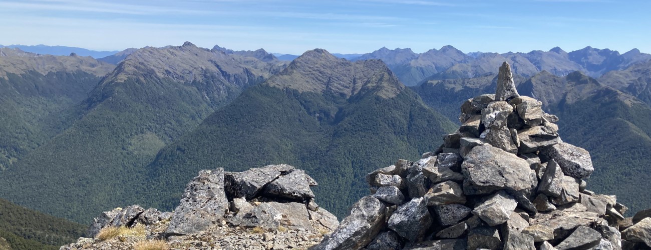
The prominence of the summit allows spectacular views north across the Inangahua Valley to the glaciated peaks and valleys of the Victoria Range, as well as the ranges encompassing Lewis Pass at the Main Divide.
Return the way you came.
Mt Haast is an alpine environment, so proper preparation and care should be made to ensure a safe trip. The track reaches a high elevation and is exposed above the tree line, so proper outdoor clothing is essential. You must always be prepared for freezing conditions and take extreme care if snow and ice and are present. Make sure you carry plenty of water with you as there are no water sources on the way up.
See the Mountain Safety Council website for useful information on preparing for the outdoors.


Mt Haast (1587 m) is a prominent peak just west of Rahu Saddle, in Victoria Forest Park. The route to the summit provides a challenging half-day walk and offers spectacular views of the surrounding ranges and valleys. Mt Haast is one of two peaks in the South Island named after Julius von Haast by 19th century explorer James MacKay.
| Details | |
| Distances | 5.5 km return |
| Time Required | 4-5 hr return |
| Trail Type | Tramping track |
| Physical Difficulty | Hard |
| Uses | Walking |
| Start Elevation | 645 m |
| Max Elevation | 1587 m |
10 min from Springs Junction | 30 min from Reefton
Mt Haast Route begins on the southern side of SH7, approx. 2 km west of Rahu Saddle. There is a parking area and a DOC sign that indicates the beginning of the route.
The route enters beech forest and begins climbing steadily. The forest understory initially features many ferns, which gradually peter out as you gain elevation. Dracophyllum and flaxes become present as you near the tree line. The track is well-worn and easy to follow, though being ‘route’ grade there are plenty of steep and rooty sections to negotiate.
After approx. 1 hr 15 min you will reach the tree line at 1250 m elevation. Above here, the route continues steeply through snow tussock and across coarse granite boulder fields. It is reasonably well-worn, though in some places the correct way forward is not immediately obvious, so you will need to rely on the occasional marker poles. This is particularly true if there is snow cover. As you climb the northeastern aspect of the peak, the spur narrows and there are steep drop-offs and gullies to be careful around.
The prominence of the summit allows spectacular views north across the Inangahua Valley to the glaciated peaks and valleys of the Victoria Range, as well as the ranges encompassing Lewis Pass at the Main Divide.
Return the way you came.
Mt Haast is an alpine environment, so proper preparation and care should be made to ensure a safe trip. The track reaches a high elevation and is exposed above the tree line, so proper outdoor clothing is essential. You must always be prepared for freezing conditions and take extreme care if snow and ice and are present. Make sure you carry plenty of water with you as there are no water sources on the way up.
See the Mountain Safety Council website for useful information on preparing for the outdoors.
Mt Haast Route does not connect to any other tracks.
Updated 17 December 2021