Mt Isobel (1319 m) forms the backdrop of Hanmer Springs. A return trip to the summit is a half-day walk and provides panoramic views of Hanmer Basin, Hanmer Range and beyond.
| Details | |
| Length | 9 km return (Mt Isobel Track) |
| Time Required | 4-5 hr return (Mt Isobel Track) |
| Trail Type | Tramping track/Poled route |
| Physical Difficulty | Moderate |
| Uses | Walking and trail running |
| Start Elevation | 530 m (Clarence Valley Rd) |
| Max Elevation | 1319 m |
| Dog Access | Dogs are permitted but must be kept under control |
If any layers fail to load, try clearing your cache and refreshing the page.
Clarence Valley Road (Jacks Pass)
Walking, trail running and MTB
Jollies Pass Road
Walking, trail running and MTB
Waterfall Track
Walking and trail running
5 min from Hanmer Springs
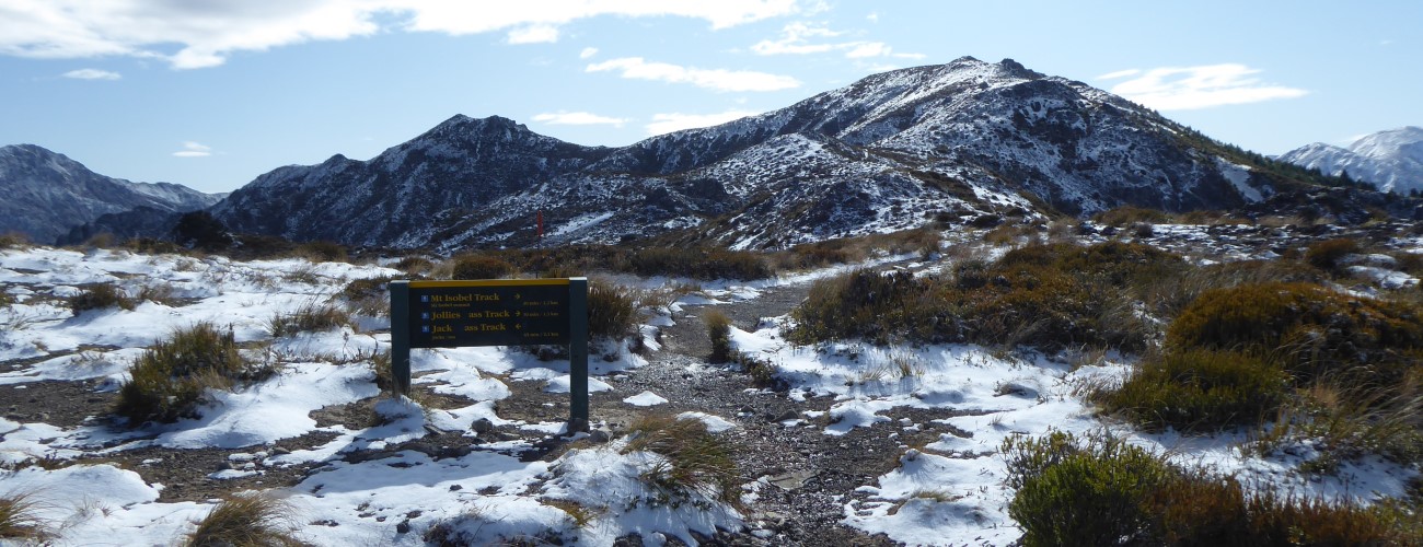
There are four ways to climb Mt Isobel; the most straight-forward and popular of these is Mt Isobel Track, which begins a short distance up Clarence Valley Rd from the village. A DOC signpost on the right side of the road indicates the track start. Another option is Waterfall Track, which begins at Dog Stream car park and connects with Mt Isobel Track near the tree line.
Another track traverses the entire summit ridge between the respective roads over Jacks Pass and Jollies Pass; this allows trips to begin at either of the latter passes, significantly reducing the amount of climbing required if you have a vehicle. Each of the tracks above can all be combined with the others to form circuits of varying length (see map).
From Clarence Valley Rd, Mt Isobel Track climbs above a felled block of forestry and gains a spur, which it zig-zags up. The vegetation is an interesting mix of native and conifer, and frequent openings allow views down to the village below. At 980 m elevation Waterfall Track connects on the right, the latter having taken a more direct route straight up Dog Stream gully. Above this junction the forest gives way to low sub-alpine scrub and the track climbs straight up to the summit ridge. Here you will reach another track junction; this time with the track that climbs from the top of Jacks Pass (2 km away).
Head right at this junction and climb the to the summit, which a small knob marked by a trig. Enjoy the views across the Hanmer Basin and north to the ranges of the Marlborough high country.
From the summit a track continues east along the ridge to Jollies Pass (2.8 km away); unless you have a vehicle to pick you up at Jollies Pass, you’ll have to factor the additional 8 km (2 hr) to get down Jollies Pass Rd and back to the village. For most people returning the way you came, back down Mt Isobel Track, is the best option.
Mt Isobel is an alpine environment, so proper preparation and care should be made to ensure a safe trip. The track reaches a high elevation and is exposed above the treeline, so proper outdoor clothing is essential. You must always be prepared for freezing conditions and take extreme care if snow and ice and are present. Do not rely on the Hanmer Springs weather forecast as the alpine conditions are likely to be drastically different. Make sure you carry plenty of water with you as there are no water sources higher up.
See the Mountain Safety Council website for useful information on preparing for the outdoors.


Mt Isobel (1319 m) forms the backdrop of Hanmer Springs. A return trip to the summit is a half-day walk and provides panoramic views of Hanmer Basin, Hanmer Range and beyond.
| Details | |
| Length | 9 km return (Mt Isobel Track) |
| Time Required | 4-5 hr return (Mt Isobel Track) |
| Trail Type | Tramping track/Poled route |
| Physical Difficulty | Moderate |
| Uses | Walking and trail running |
| Start Elevation | 530 m (Clarence Valley Rd) |
| Max Elevation | 1319 m |
| Dog Access | Dogs are permitted but must be kept under control |
5 min from Hanmer Springs
There are four ways to climb Mt Isobel; the most straight-forward and popular of these is Mt Isobel Track, which begins a short distance up Clarence Valley Rd from the village. A DOC signpost on the right side of the road indicates the track start. Another option is Waterfall Track, which begins at Dog Stream car park and connects with Mt Isobel Track near the tree line.
Another track traverses the entire summit ridge between the respective roads over Jacks Pass and Jollies Pass; this allows trips to begin at either of the latter passes, significantly reducing the amount of climbing required if you have a vehicle. Each of the tracks above can all be combined with the others to form circuits of varying length (see map).
From Clarence Valley Rd, Mt Isobel Track climbs above a felled block of forestry and gains a spur, which it zig-zags up. The vegetation is an interesting mix of native and conifer, and frequent openings allow views down to the village below. At 980 m elevation Waterfall Track connects on the right, the latter having taken a more direct route straight up Dog Stream gully. Above this junction the forest gives way to low sub-alpine scrub and the track climbs straight up to the summit ridge. Here you will reach another track junction; this time with the track that climbs from the top of Jacks Pass (2 km away).
Head right at this junction and climb the to the summit, which a small knob marked by a trig. Enjoy the views across the Hanmer Basin and north to the ranges of the Marlborough high country.
From the summit a track continues east along the ridge to Jollies Pass (2.8 km away); unless you have a vehicle to pick you up at Jollies Pass, you’ll have to factor the additional 8 km (2 hr) to get down Jollies Pass Rd and back to the village. For most people returning the way you came, back down Mt Isobel Track, is the best option.
Mt Isobel is an alpine environment, so proper preparation and care should be made to ensure a safe trip. The track reaches a high elevation and is exposed above the treeline, so proper outdoor clothing is essential. You must always be prepared for freezing conditions and take extreme care if snow and ice and are present. Do not rely on the Hanmer Springs weather forecast as the alpine conditions are likely to be drastically different. Make sure you carry plenty of water with you as there are no water sources higher up.
See the Mountain Safety Council website for useful information on preparing for the outdoors.
Clarence Valley Road (Jacks Pass)
Walking, trail running and MTB
Jollies Pass Road
Walking, trail running and MTB
Waterfall Track
Walking and trail running
Updated 30 March 2020