Barnicoat Road begins in Aniseed Valley near Roding Dam and climbs the eastern side of Barnicoat Range, linking with Barnicoat Walkway at the top. The forestry road is a great link that allows rides and trail running circuits between Aniseed Valley and Barnicoat Range.
| Details | |
| Length | 4.2 km one way |
| Time Required | 30 – 45 min going up |
| Uses | Trail running and MTB |
| Trail Type | Gravel road |
| Physical Difficulty | Moderate |
| Technical Difficulty | Easy |
| Direction | Either |
| Start Elevation | 175 m |
| Finish Elevation | 500 m |
If any layers fail to load, try clearing your cache and refreshing the page.
30 min from Nelson (Aniseed Valley start)
Barnicoat Road is located near the end of Aniseed Valley Road, 19.3 km from Richmond. The road begins 5.3 km from Hacket car park and 2.1 km before the Roding Dam car park. It is open to the public though the surrounding hillside is managed by Hancock Forest Management. The road may close occasionally due to forestry operations or fire risk in summer.
There is no parking, though it is not the sort of road you would go specifically to do; rather, you would combine it with Aniseed Valley and Barnicoat Range to create a varied circuit from the city. If you’re on foot, a good idea is to get dropped at Hacket car park and run up Aniseed Valley Road to the start of Barnicoat Road (the road is quiet but take care regardless).
Barnicoat Road starts climbing immediately from Aniseed Valley Road. There is a gate across the road preventing vehicle access. There is a road junction just after the gate, with Couch Road going left and Barnicoat Road (not signposted) going right. Make sure you turn right here, even though Couch Road looks to be in better condition than Roding Road.
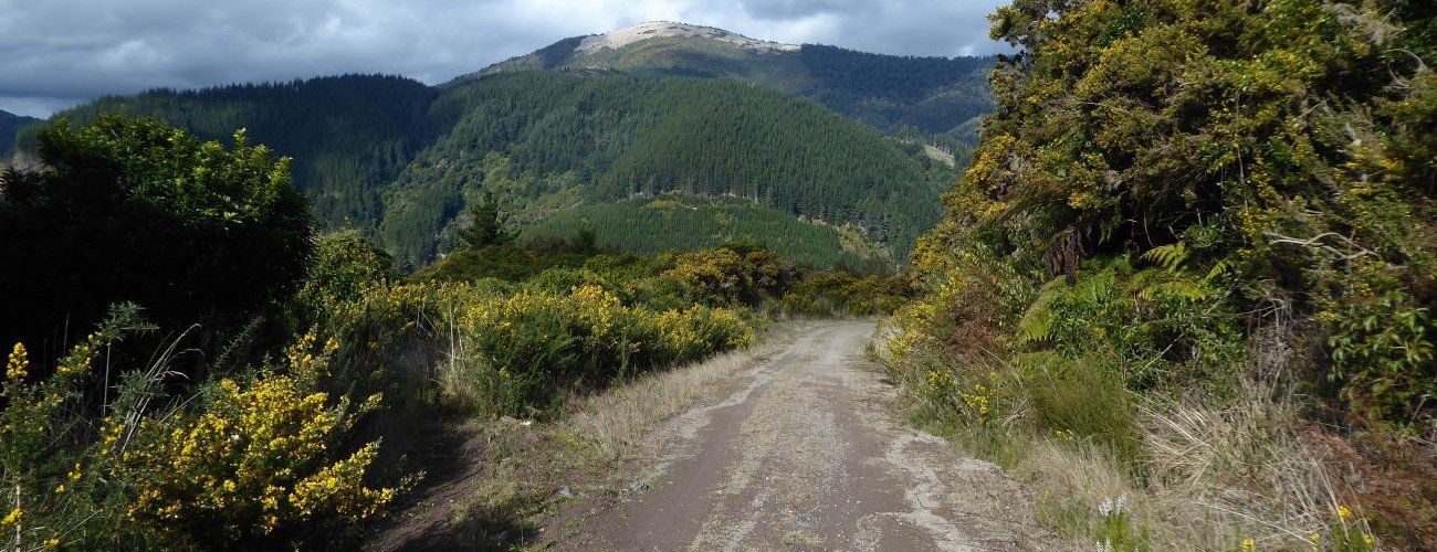
Barnicoat Road climbs the range through felled pine forest and then low native trees and scrub higher up. The gradient is not too steep and is consistent the whole way up. At the top of the range the road connects with Barnicoat Walkway. From here you can head left (south) to Silvan MTB Park and Richmond Fire Lookout, or right (north) to the paragliding area at the top of Glider Road, and further to Jenkins Hill.
Barnicoat Road begins in Aniseed Valley near Roding Dam and climbs the eastern side of Barnicoat Range, linking with Barnicoat Walkway at the top. The forestry road is a great link that allows rides and trail running circuits between Aniseed Valley and Barnicoat Range.
| Details | |
| Length | 4.2 km one way |
| Time Required | 30 – 45 min going up |
| Uses | Trail running and MTB |
| Trail Type | Gravel road |
| Physical Difficulty | Moderate |
| Technical Difficulty | Easy |
| Direction | Either |
| Start Elevation | 175 m |
| Finish Elevation | 500 m |
30 min from Nelson (Aniseed Valley start)
Barnicoat Road is located near the end of Aniseed Valley Road, 19.3 km from Richmond. The road begins 5.3 km from Hacket car park and 2.1 km before the Roding Dam car park. It is open to the public though the surrounding hillside is managed by Hancock Forest Management. The road may close occasionally due to forestry operations, or fire risk in summer.
There is no parking, though it is not the sort of road you would go specifically to do; rather, you would combine it with Aniseed Valley and Barnicoat Range to create a varied circuit from the city. If you’re on foot, a good idea is to get dropped at Hacket car park and run up Aniseed Valley Road to the start of Barnicoat Road (the road is quiet but take care regardless).
Barnicoat Road starts climbing immediately from Aniseed Valley Road. There is a gate across the road preventing vehicle access. There is a road junction just after the gate, with Couch Road going left and Barnicoat Road (not signposted) going right. Make sure you turn right here, even though Couch Road looks to be in better condition than Roding Road.
Barnicoat Road climbs the range through felled pine forest and then low native trees and scrub higher up. The gradient is not too steep and is consistent the whole way up. At the top of the range the road connects with Barnicoat Walkway. From here you can head left (south) to Silvan MTB Park and Richmond Fire Lookout, or right (north) to the paragliding area at the top of Glider Road, and further to Jenkins Hill.
Updated 2 July 2020