Maungatapu Circuit traverses Bryant Range, in the Maitai Water Reserve east of central Nelson. The circuit incorporates Rush Pool Track and Maungatapu Track, via Dew Lakes and the peak of Maungatapu (1014 m). It is a quieter alternative to nearby Coppermine Trail, whilst still showcasing the fascinating mineral belt landscape and mossy beech forest along the crest of Bryant Range. There are several other ways you can utilise the track network to create different half-day to full-day walking circuits.
| Details | |
| Distances | 6.3 km Rush Pool return; 18.6 km full circuit via Dew Lakes and Maungatapu Saddle |
| Time Required | 2 hr 30 min Rush Pool return; full circuit via Dew Lakes and Maungatapu Saddle |
| Trail Type | Tramping track/4WD road |
| Physical Difficulty | Hard |
| Uses | Walking and trail running |
| Direction | Either |
| Start Elevation | 120 m (Maitai Dam) |
| Max Elevation | 1014 m (Maungatapu) |
If any layers fail to load, try clearing your cache and refreshing the page.
20 min from central Nelson
Maungatapu Circuit is accessed from the end of Maitai Valley, which is 11 km up Maitai Valley Road from central Nelson. Use the car park just after Maungatapu Road turnoff, or if the gate is open, continue to the car park on the other side of the dam spillway. Take note of the signage that warns the gate will be closed at 5 PM.
The majority of the circuit is within Nelson City Council’s Maitai Water Reserve. Along the top of Bryant Range between the Dew Lakes junction and Maungatapu Saddle, the track skirts back and forth across the Mt Richmond Forest Park boundary, which roughly follows the top of the range.
This circuit can be completed in either direction; though the description below describes taking Rush Pool Track on the uphill leg, Maungatapu Track is steeper and may in fact be preferable for some people to climb up rather than come down.
From the dam car park, head along the gravel road on the other side of the gate, which climbs steadily through a block of recently-felled pine forest before gaining the top of a spur. Here, Rush Pool Track branches off to the right and continues through mineral belt scrub to the Rush Pool and a historic Maori argillite quarry. The Rush Pool was created by Maori in the 16th century to help quarry argillite. The quarrying process involved lighting a fire beneath rock outcrops to heat them, then dousing the rock with cold water from the pool, causing shards to split and crack off. A return trip to the Rush Pool alone will take you around 2 hr 30 min.
The track continues uphill, alternating between beech forest and mineral belt scrub. It is very rutted in places, and at times is literally a creek bed. You will reach a junction with Dun Saddle-Maungatapu Saddle Track at the top of Bryant Range (940 m elevation) after 2-3 hours. Turn left (north) here to continue toward Maungatapu Saddle.
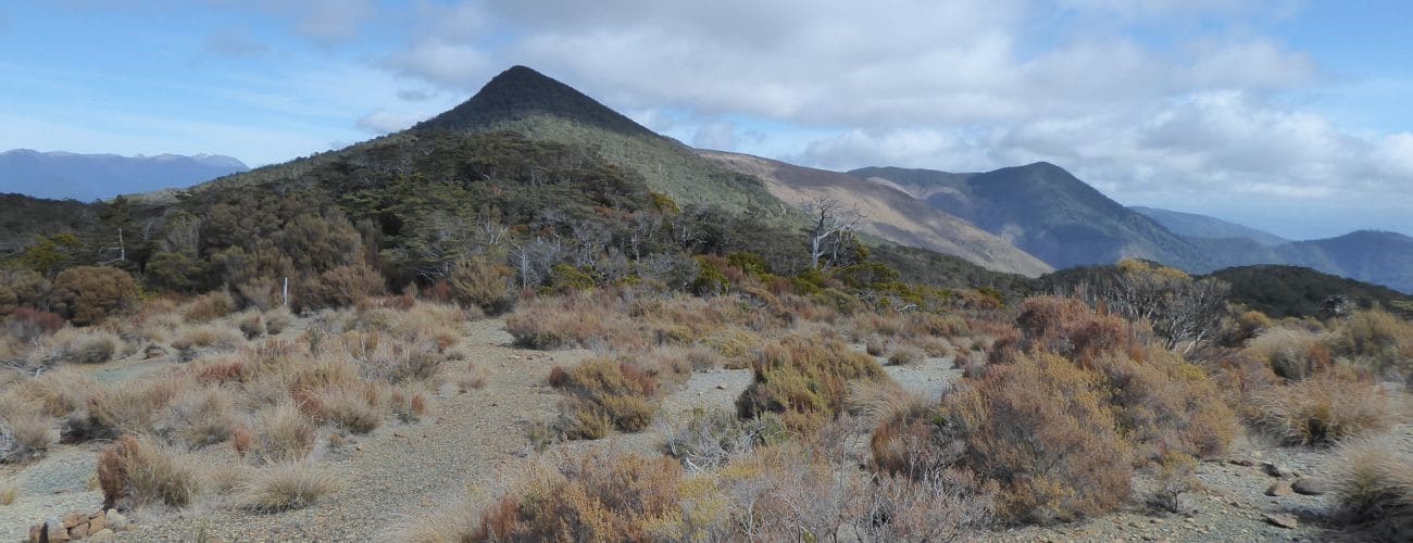
Dew Lakes are a short distance from the junction. While their name is somewhat misleading (‘ponds’ would be a more appropriate title), they provide a convenient place to stop for a lunch break. The track then climbs over the highest point of the circuit, Maungatapu summit (1014 m). A rocky outcrop opens among the trees and allows views across the upper Maitai catchment. The track descends from Maungatapu into a saddle and climbs again along the range through beech forest, and then descends to Maungatapu Saddle.
From here it is an easy walk back down Maungatapu Track, which is a wide 4WD road all the way back to the junction next to the caretaker’s house; here you can continue straight along the road that drops down to the dam crest and leads back to both car parks.
From Maungatapu Saddle you can also continue along the ridge on Saddle Hill Route (the Doubles), which climbs to the South Double (1168 m). While the distance is only 2 km, the climb is steep and challenging; allow at least an 1 hr 30 min to reach the summit.


Maungatapu Circuit traverses Bryant Range, in the Maitai Water Reserve east of central Nelson. The circuit incorporates Rush Pool Track and Maungatapu Track, via Dew Lakes and the peak of Maungatapu (1014 m). It is a quieter alternative to nearby Coppermine Trail, whilst still showcasing the fascinating mineral belt landscape and mossy beech forest along the crest of Bryant Range. There are several other ways you can utilise the track network to create different half-day to full-day walking circuits.
| Details | |
| Distances | 6.3 km Rush Pool return; 18.6 km full circuit via Dew Lakes and Maungatapu Saddle |
| Time Required | 2 hr 30 min Rush Pool return; full circuit via Dew Lakes and Maungatapu Saddle |
| Trail Type | Tramping track/4WD road |
| Physical Difficulty | Hard |
| Uses | Walking and trail running |
| Direction | Either |
| Start Elevation | 120 m (Maitai Dam) |
| Max Elevation | 1014 m (Maungatapu) |
20 min from central Nelson
Maungatapu Circuit is accessed from the end of Maitai Valley, which is 11 km up Maitai Valley Road from central Nelson. Use the car park just after Maungatapu Road turnoff, or if the gate is open, continue to the car park on the other side of the dam spillway. Take note of the signage that warns the gate will be closed at 5 PM.
The majority of the circuit is within Nelson City Council’s Maitai Water Reserve. Along the top of Bryant Range between the Dew Lakes junction and Maungatapu Saddle, the track skirts back and forth across the Mt Richmond Forest Park boundary, which roughly follows the top of the range.
This circuit can be completed in either direction; though the description below describes taking Rush Pool Track on the uphill leg, Maungatapu Track is steeper and may in fact be preferable for some people to climb up rather than come down.
From the dam car park, head along the gravel road on the other side of the gate, which climbs steadily through a block of recently-felled pine forest before gaining the top of a spur. Here, Rush Pool Track branches off to the right and continues through mineral belt scrub to the Rush Pool and a historic Maori argillite quarry. The Rush Pool was created by Maori in the 16th century to help quarry argillite. The quarrying process involved lighting a fire beneath rock outcrops to heat them, then dousing the rock with cold water from the pool, causing shards to split and crack off. A return trip to the Rush Pool alone will take you around 2 hr 30 min.
The track continues uphill, alternating between beech forest and mineral belt scrub. It is very rutted in places, and at times is literally a creek bed. You will reach a junction with Dun Saddle-Maungatapu Saddle Track at the top of Bryant Range (940 m elevation) after 2-3 hours. Turn left (north) here to continue toward Maungatapu Saddle.
Dew Lakes are a short distance from the junction. While their name is somewhat misleading (‘ponds’ would be a more appropriate title), they provide a convenient place to stop for a lunch break. The track then climbs over the highest point of the circuit, Maungatapu summit (1014 m). A rocky outcrop opens among the trees and allows views across the upper Maitai catchment. The track descends from Maungatapu into a saddle and climbs again along the range through beech forest, and then descends to Maungatapu Saddle.
From here it is an easy walk back down Maungatapu Track, which is a wide 4WD road all the way back to the junction next to the caretaker’s house; here you can continue straight along the road that drops down to the dam crest and leads back to both car parks.
From Maungatapu Saddle you can also continue along the ridge on Saddle Hill Route (the Doubles), which climbs to the South Double (1168 m). While the distance is only 2 km, the climb is steep and challenging; allow at least an 1 hr 30 min to reach the summit.