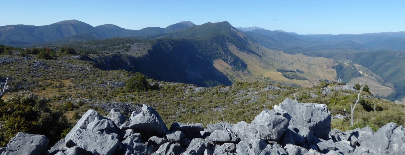
Takaka Hill Walkway is a loop walk at the top of Takaka Hill. The walkway passes through fascinating karst landscape, with intriguing marble rock formations, sub-alpine scrub and beech forest, and magnificent views of Kahurangi National Park and Takaka Valley. The walkway is public, though it is located on private land owned by the Harwood family. This land was protected with three QEII Open Space Covenants in 1985, in recognition of the outstanding karst landscape and unusual geology. The covenant land borders Kahurangi National Park to the south and east. The walkway is maintained by the QEII National Trust and volunteers.
| Details | |
| Length | 3 km for half loop; 5.1 km for full loop |
| Time Required | 1-2 hr for half loop; 2-3 hr for full loop |
| Trail Type | 4WD road/Walking track |
| Physical Difficulty | Moderate |
| Uses | Walking only |
| Direction | Either |
| Start Elevation | 805 m |
| Max Elevation | 950 m |
| Amenities | There are no toilets or drinking water sources on the walkway |
If any layers fail to load, try clearing your cache and refreshing the page.
This elevation profile should be considered approximate. Its accuracy is determined by the quality of data available.
Takaka Hill Walkway does not connect to any other tracks.
1 hr from Nelson | 30 min from Takaka
Takaka Hill Walkway is located at the top of Takaka Hill on State Highway 60, 53 km from Richmond and 38 km from Takaka. The walkway has its own car park on the left side of the road (if you’re coming from Nelson), which is signposted. Allow 1 hour to get to the walkway if you’re coming from Nelson, or 30 min if you’re coming from Takaka.
The beginning of the walkway follows a 4WD road. The road heads to the left, but continue to the right (following the signposts), which takes a more direct route uphill. After 600 m the walkway rejoins the 4WD and curves around to the west to overlook Takaka Valley. Take a short deviation up the road to a radio tower, situated atop a knob at 950 m elevation. Here you will enjoy magnificent views of the upper Takaka Valley, Golden Bay and the Tasman Mountains in Kahurangi National Park.
The walkway continues down around the high point, clambering around and over coarse marble through dense scrub. A little further on you will enter a section of native forest, and then reach a link track that heads back to the 4WD road (which you can take to get back to the car park). Otherwise continue along the walkway, as it heads east through karst, scrub and beech forest, and loops back to the 4WD road after 2 km.
The walkway is well signposted the whole way around. It does not allow for fast travel; pay attention to where you place your feet, as the oddly-shaped rock formations and uneven track can easily cause falls and twisted ankles.
Do not venture off the track. Sometimes referred to as ‘Marble Mountain’, Takaka Hill is dotted with numerous sinkholes, many of which are obscured by vegetation and rocks. Some of these are extremely deep, and though there are some warning signs in place, do not rely solely on these for your safety. The walkway is entirely above 800 m elevation and the higher section around the radio tower is very exposed, so be sure to bring appropriate warm clothing as the weather may turn unexpectedly. Make sure you wear sturdy outdoor footwear as the walkway is rough and uneven. There are no water sources, so bring plenty of your own.
Note that there is actually no officially-gazetted geographic location called ‘Takaka Hill’. The name generally refers to the entire upland area that SH60 traverses between Riuwaka Valley and Upper Takaka. In July 2020 the name ‘Tākaka Hill Saddle’ was officially applied to the 791 m saddle that the highway crosses, just past the walkway car park (this is highest elevation the highway reaches). This is the only geographic feature that officially bears the name ‘Takaka Hill’.
The 950 m elevation knob that hosts the radio tower is the highest elevation point of anywhere across the karst plateau (aside from the Pikikirunga Range to the north) and given its proximity to the saddle, it is probably the logical contender for laying claim to the title of unofficial summit of Takaka Hill.


Takaka Hill Walkway is a loop walk at the top of Takaka Hill. The walkway passes through fascinating karst landscape, with intriguing marble rock formations, sub-alpine scrub and beech forest, and magnificent views of Kahurangi National Park and Takaka Valley. The walkway is public, though it is located on private land owned by the Harwood family. This land was protected with three QEII Open Space Covenants in 1985, in recognition of the outstanding karst landscape and unusual geology. The covenant land borders Kahurangi National Park to the south and east. The walkway is maintained by the QEII National Trust and volunteers.
| Details | |
| Length | 3 km for half loop; 5.1 km for full loop |
| Time Required | 1-2 hr for half loop; 2-3 hr for full loop |
| Trail Type | 4WD road/Walking track |
| Physical Difficulty | Moderate |
| Uses | Walking only |
| Direction | Either |
| Start Elevation | 805 m |
| Max Elevation | 950 m |
| Amenities | There are no toilets or drinking water sources on the walkway |
This elevation profile should be considered approximate. Its accuracy is determined by the quality of data available.
1 hr from Nelson | 30 min from Takaka
Takaka Hill Walkway is located at the top of Takaka Hill on State Highway 60, 53 km from Richmond and 38 km from Takaka. The walkway has its own car park on the left side of the road, which is signposted. Allow 1 hour to get to the walkway if you’re coming from Nelson, or 30 min if you’re coming from Takaka.
The beginning of the walkway follows a 4WD road. The road heads to the left, but continue to the right (following the signposts), which takes a more direct route uphill. After 600 m the walkway rejoins the 4WD and curves around to the west to overlook Takaka Valley. Take a short deviation up the road to a radio tower, situated atop a knob at 950 m elevation. Here you will enjoy magnificent views of the upper Takaka Valley, Golden Bay and the Tasman Mountains in Kahurangi National Park.
The walkway continues down around the high point, clambering around and over coarse marble through dense scrub. A little further on you will enter a section of native forest, and then reach a link track that heads back to the 4WD road (which you can take to get back to the car park). Otherwise continue along the walkway, as it heads east through karst, scrub and beech forest, and loops back to the 4WD road after 2 km.
The walkway is well signposted the whole way around. It does not allow for fast travel; pay attention to where you place your feet, as the oddly-shaped rock formations and uneven track can easily cause falls and twisted ankles.
Do not venture off the track. Sometimes referred to as ‘Marble Mountain’, Takaka Hill is dotted with numerous sinkholes, many of which are obscured by vegetation and rocks. Some of these are extremely deep, and though there are some warning signs in place, do not rely solely on these for your safety. The walkway is entirely above 800 m elevation and the higher section around the radio tower is very exposed, so be sure to bring appropriate warm clothing as the weather may turn unexpectedly. Make sure you wear sturdy outdoor footwear as the walkway is rough and uneven. There are no water sources, so bring plenty of your own.
Note that there is actually no officially-gazetted geographic location called ‘Takaka Hill’. The name generally refers to the entire upland area that SH60 traverses between Riuwaka Valley and Upper Takaka. In July 2020 the name ‘Tākaka Hill Saddle’ was officially applied to the 791 m saddle that the highway crosses, just past the walkway car park (this is highest elevation the highway reaches). This is the only geographic feature that officially bears the name ‘Takaka Hill’.
The 950 m elevation knob that hosts the radio tower is the highest elevation point of anywhere across the karst plateau (aside from the Pikikirunga Range to the north) and given its proximity to the saddle, it is probably the logical contender for laying claim to the title of unofficial summit of Takaka Hill.
Takaka Hill Walkway does not connect to any other tracks.
Updated 23 August 2020